In addition to our group of speakers and the exhibitors in our See-Through Maps exhibit, many of our attendees at Mapping and Its Discontents also make and mash-up maps. We've asked our attendees at the symposium to contribute some of their own work, and we are sharing them with you here. If you attended the symposium and would like to share your work here, please send us an email at globalurbanhumanities@berkeley.edu.
Thomas Bachand
 Author, photographer, and web developer Thomas Bachand has created the Keystone Mapping Project (KMP), an internationally recognized multimedia and photography project examining land use and climate change in America through an exploration of the Keystone XL – the proposed 2,000 mile diluted bitumen pipeline that bisects the North American Continent. The controversial pipeline has become emblematic of our inability to reconcile world demand for fossil fuels and the environmental imperatives imposed upon modern civilization. The KMP has established itself as the most comprehensive publicly-available mapping resource for the pipeline. The project’s website and interactive mapping application form the foundation of the project, allowing communities, stakeholders, journalists and non-profits to more easily evaluate the pipeline and its impacts and identify and cooperatively address common issues.
Val Britton

 Val Britton is a San Francisco-based artist working with large scale, mixed media collage and site-specific installation. Much of Val's work engages with the language of mapping, initially inspired by her father's travels as a cross-country truck driver. Her pieces map imaginary landscapes, physical and psychological spaces. Val's work can be seen on her website as well as through her gallery, Gallery Wendi Norris.
Alexander Craghead
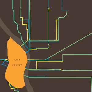
 Alexander Craghead is a graduate student in the Masters of Science in Architecture program at UC Berkeley, where he is studying architectural and urban history. He previously taught at Marylhurst University, a private liberal arts school in Oregon, from which he also received his BA in communications. Alex is interested in how maps can clarify, through selective inclusion, the relationships of places over time, especially in connection to transportation and land use. More of his maps can be seen on his Flickr page and his personal website.
Chris Henrick

 Chris Henrick studied fine art and geography, then began a career in cartography by interning with the mapping and GIS non-profit firm GreenInfo Network in San Francisco, CA. Following GreenInfo, Chris worked for several years for travel guide publisher Avalon Travel in Berkeley, CA producing maps for their print and e-books, and consultanted for others such as the Oakland Museum of California. Chris is currecntly pursuing an MFA in Design and Technology at Parsons, the New School For Design in New York City, focusing on exploring web-development, open-source GIS and cartography software, and open-data, with the intention of using cartography as a tool for social justice. More of Chris' work can be seen on his personal website as well as on his Behance page.
Darin Jensen

 Darin Jensen is a continuing lecturer and department cartographer at the UC Berkeley Department of Geography. Darin's work includes co-editing Food: An Atlas (2013), a collection of maps about food and geography. He also edited and parciticipated in the creation of Mission Possible: A Neighborhood Atlas (2011), which explores the many ways that maps can be used to express San Francisco's Mission District. Darin's complete CV can be found here.
Lauren McQuistion

 Lauren McQuistion is an artist and designer with a background in architecture. Her personal practice includes both analytical and conceptual mapping, using drawing, collage, and mixed media paintings to investigate her interest in design agency, public space, and experiential landscapes. More of her work can be seen on her web site.
Lize Mogel

 Artist Lize Mogel straddles the fields of art and cultural geography, creating “counter cartography,” mapping that challenges the mainstream narrative of a site or history and offers new understandings of social and political issues. She connects the real history of and our collective imaginary about specific places to larger narratives of global economies. Mogel uses conventional maps as readymades, appropriating them in order to examine the power relations they contain and to reconfigure them into new geographies. She inserts her counter-cartographies into public spaces and distributes them via publications. Her work can be on her web site, and in An Atlas of Radical Cartography.
Laci Videmsky

 Laci Videmsky explores innovative ways to activate citizens to participate in changing government using technology and new forms of community engagement. Currently, Laci is working on a platform for the state of California that makes water understandable, data accessible, and underrepresented communities included in the ongoing water debate. Recent coverage of Laci's work can be seen on Wired and in the Fairfield-Suisin Daily Republic, and his work can be seen on the California Water Atlas.